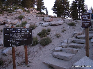
This is one of the best hikes I have done in years. There are a couple options with this hike - its an easy hike to the falls (about 5 miles round-trip) or you can continue up to the summit of Mt Rose for about 10 miles round-trip. The hike to the falls is fairly easy, but the rest of the hike to the summit is moderate. The hike starts at 8,700 feet elevation - the summit is 10,778 feet.
The trailhead is around the road side of the building. Take the Mt. Rose Summit trail to the right. This is a hiker only trail, no mountain bikes allowed.
 The first 2.5 miles of the hike is fairly nice with some early views of Lake Tahoe and a daunting view of Mt Rose ahead.
After passing Galena Falls, continue to the right at the intersection of the Tahoe Rim Trail (leading to Relay Peak).

After crossing Galena Creek, the hike starts to get serious. There are a few shady spots on this part of the hike, but be prepared for lots of full sun areas. Along the way we saw plenty of chipmunks running around. The wildflowers (which are great in the early summer) were almost all past bloom in late August.
 After passing into the signed Mt Rose Wilderness Area (Toiyabe National Forest), there is a final right turn up to the Summit. It may seem like there are still miles to go to reach the top of Mt Rose, but really at this point there is only 1.2 miles left to the summit.
This part of the trail has a number of easy switchbacks up the mountain. The trail leads around the backside/northside of the mountain. At this point, you are exposed to the sun and wind. On the day we hiked it was very windy.
From this part of the hike you can see north toward Truckee. You can see Donner Lake, Boca Reservoir, Prosser Creek Reservoir, and Stampede Reservoir, plus the top of Mount Lassen on a very clear day.
 The trail rounds the mountain and goes up the spine of the summit- again it can get very windy here. There are two main areas at the top of Mt Rose, both with rock-built shelters to shield you from the wind.
 The views on this day were fantastic and basically unlimited. You could see Lake Tahoe, Virgina City, Reno, and Washoe Lake. It was one of the best views I have ever seen.
To return to the trailhead, just head back down the way you came up. To really enjoy this hike, I would suggest doing it VERY early during the summer (we started at 6am). The crowds are less and temperature is still cool. It can get hot on this hike past Noon during the summer.
Since you will reach 10,000 feet, be sure to bring sunglasses and water for this hike.
The trek up the mountain looks very daunting from the parking lot and during the first half of the hike -- but thanks to the switchbacks its not too difficult. For an easier option, just hike to the falls and enjoy all the scenery except for the 360 views at the top.
Map:
View Mt Rose Hike in a larger map
Basics:
Area - Toiyabe National Forest- Mount Rose Wilderness
Trails - Mt Rose Summit Trail
Map - Tahoe Rim Trail Map
Length - 10 miles out and back to the summit
Trail - Well maintained dirt trail, loose rock at the summit
Dogs - Yes, on a leash (no water after first 2.5 miles)
Bikes - Not allowed
Views - This hike is ALL Views
Getting There - At the summit of Highway 431 between Reno and Incline Village
Fee- None, free parking
Weather - Full sun
Other Trails - A couple including a connector trail to the Tahoe Meadows Interpretive Loop
Facilities - restrooms at the trailhead/parking lot.